See every stressed zone in your field before it costs you.
Multispectral NDVI drone scans for South Texas farmers. Color map and PDF report in 48 hours. Starting at $7/acre, no contracts.
Call or text: (956) 332-3659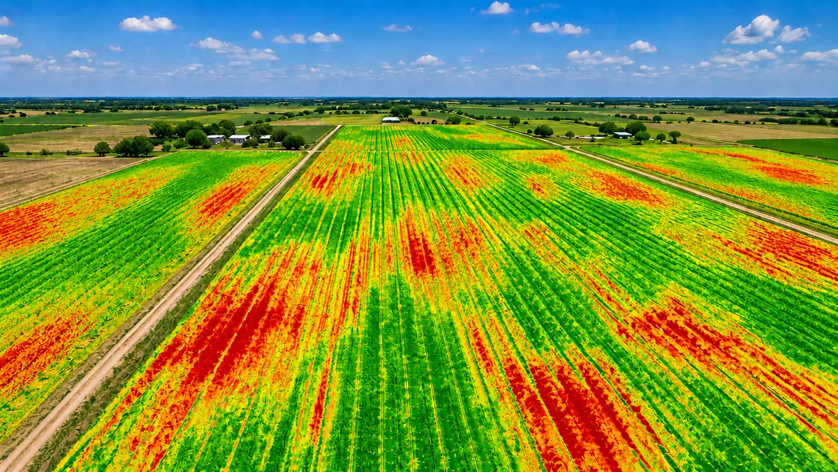
Get a Free Quote
How it works
You tell us your field location and acreage. We schedule a flight around the weather and your timeline.
We fly your field with our DJI Mavic 3 Multispectral and RTK module. The whole scan takes about an hour per 100 acres.
You get a color NDVI map, a shapefile, and an annotated PDF report within 48 hours. That is it.
What You Get
Catching a pest outbreak or disease pressure two to three weeks early can save thousands of dollars in a single season. Farmers who scan get higher yields by treating only the zones that actually need it.
- Color NDVI map showing healthy, stressed, and dry zones
- Shapefile for use in precision ag software
- Annotated PDF report with zone-by-zone notes
- Third-party documentation for crop insurance claims
- FAA Part 107 certified flight log on request
- No contracts
- No hidden fees
- Delivered in 48 hours
- One price, all crops
Starting at $7/acre · No contracts · 48 hours
Common questions
- What is NDVI drone scanning?
- NDVI stands for Normalized Difference Vegetation Index. Our drone captures light your eye cannot see and turns it into a color map of your field. Green zones are healthy. Yellow and red zones are stressed, dry, or diseased. Catching a problem two to three weeks early can save thousands of dollars in a single season.
- How much does it cost?
- We charge starting at $7 per acre. No contracts, no hidden fees. Most fields in the Rio Grande Valley come out between $150 and $700 for a single scan.
- How fast do I get my results?
- We deliver your color NDVI map and PDF report within 48 hours of the flight. Most jobs are done faster than that.
- Will my crop insurance adjuster accept this?
- Yes. Our reports come from a third-party FAA Part 107 licensed operator using calibrated multispectral sensors. The NDVI data and georeferenced maps are in the standard formats adjusters use for crop loss claims.
- Do I need to be there when you fly?
- No. We just need the field location, your contact info, and permission to fly. We take care of everything and send your report when it is done.
- What crops do you scan?
- We scan dryland row crops, irrigated fields, and pasture or rangeland. Sorghum, cotton, small grains, onions, sugarcane, native pasture. If it grows in South Texas, we can scan it.
FAA Part 107 Licensed · DJI Mavic 3 Multispectral · RTK Accuracy 2 to 5 cm · Rio Grande Valley, TX